Long Island (Long Island)
Long Island is about 130 kilometers (80 mi) long and 6 km wide at its widest point. The land area is 596 km2. Long Island is situated about 265 km southeast of the Bahamian capital of Nassau, which is located on the island of New Providence. The Tropic of Cancer runs through the northern quarter of the island.
The northeast side of Long Island is noted for its steep rocky headlands, while the southwest coast is noted for its broad white beaches with soft sand. The terrain ranges widely throughout the island, including white flat expanses from which salt is extracted, swamplands, beaches, and sloping (in the north) and low (in the south) hills.
Long Island is particularly noted for its caves, which have played a major role in the island's history. Dean's Blue Hole, located west of Clarence Town, is the world's second deepest underwater sinkhole, dropping to a depth of about 200 meters, making it more than double the depth of most other large holes.
Long Island is surrounded by small bays and inlets, including the large New Found Harbour west of Deadman's Cay, at approximately the midsection of the island. There are also smaller islands off-shore, including Sandy Cay.
Map - Long Island (Long Island)
Map


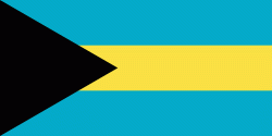
Country - The_Bahamas
 |
 |
The Bahama Islands were inhabited by the Lucayans, a branch of the Arawakan-speaking Taíno, for many centuries. Christopher Columbus was the first European to see the islands, making his first landfall in the "New World" in 1492 when he landed on the island of San Salvador. Later, the Spanish shipped the native Lucayans to and enslaved them on Hispaniola, after which the Bahama islands were mostly deserted from 1513 until 1648, nearly all native Bahamians having been forcibly removed for enslavement or having died of diseases that Europeans brought to the islands. In 1649, English colonists from Bermuda, known as the Eleutheran Adventurers, settled on the island of Eleuthera.
Currency / Language
| ISO | Currency | Symbol | Significant figures |
|---|---|---|---|
| BSD | Bahamian dollar | $ | 2 |
| ISO | Language |
|---|---|
| EN | English language |